


HAMLIN TWP Voting District, Audubon County, Iowa
About
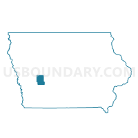
Outline

Summary
| Unique Area Identifier | 581412 |
| Name | HAMLIN TWP Voting District |
| County | Audubon County |
| State | Iowa |
| Area (square miles) | 35.81 |
| Land Area (square miles) | 35.79 |
| Water Area (square miles) | 0.02 |
| % of Land Area | 99.94 |
| % of Water Area | 0.06 |
| Latitude of the Internal Point | 41.64322300 |
| Longtitude of the Internal Point | -94.92334610 |
Maps


Graphs
Select a template below for downloading or customizing gragh for HAMLIN TWP Voting District, Audubon County, Iowa


Neighbors
Neighoring Voting District (by Name) Neighboring Voting District on the Map
- DOUGLAS TWP Voting District, Audubon County, IA
- EXIRA TWP W/O BRAYTON Voting District, Audubon County, IA
- GREELEY TWP Voting District, Audubon County, IA
- LEROY TWP Voting District, Audubon County, IA
- MELVILLE TWP Voting District, Audubon County, IA
- OAKFIELD TWP W/O BRAYTON Voting District, Audubon County, IA
- SHARON TWP Voting District, Audubon County, IA
Top 10 Neighboring County Subdivision (by Population) Neighboring County Subdivision on the Map
- Leroy township, Audubon County, IA (2,496)
- Exira township, Audubon County, IA (1,178)
- Sharon township, Audubon County, IA (584)
- Oakfield township, Audubon County, IA (314)
- Hamlin township, Audubon County, IA (252)
- Douglas township, Audubon County, IA (210)
- Greeley township, Audubon County, IA (170)
- Melville township, Audubon County, IA (117)
Top 10 Neighboring Unified School District (by Population) Neighboring Unified School District on the Map
Top 10 Neighboring State Legislative District Lower Chamber (by Population) Neighboring State Legislative District Lower Chamber on the Map
Top 10 Neighboring State Legislative District Upper Chamber (by Population) Neighboring State Legislative District Upper Chamber on the Map
Top 10 Neighboring 111th Congressional District (by Population) Neighboring 111th Congressional District on the Map
Top 10 Neighboring Census Tract (by Population) Neighboring Census Tract on the Map
- Census Tract 702, Audubon County, IA (2,332)
- Census Tract 701, Audubon County, IA (2,056)
- Census Tract 703, Audubon County, IA (1,731)